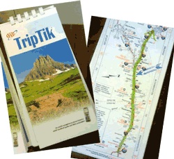
A few years ago, while we were getting ready to drive to New York City for the day, one of my sons asked me how we used to know how to get places before Google Maps.
The question caught me by surprise, since I had never really given it much thought, and so I really couldn’t give him a good answer. I know for longer trips we would go the local AAA office and get a custom trip-tik created for us. The trip-tik had a series of mini-maps, one map per page, with the required route highlighted on each map. You would then flip the page over to go to the next segment of the trip.
But what did I do about shorter trips, for example, going from my house to a restaurant or friend’s house for the first time? I certainly wouldn’t go to AAA to get directions for a trip like that.
In the back of my mind, it seemed like I just knew; but somewhere along the way, I had to have learned that route. I am sure many times I relied on my dad to tell me how to get places, since he seemed to know multiple ways to get everywhere within 50 miles of our house. I am sure other times I would call someone at the place I was going to and ask for directions. But how did the person on the other end of the phone know?
Anyway, what amazes me is that I really have little to no recollection of how I figured out how to get from point A to point B, before Google (B.G.).
Today, I use Google Maps all the time, even when I already know how to get to where I’m headed. With its real-time traffic info, it may recommend an alternative route compared to the one I would have used if I had not consulted Google Maps.
We’ve used it to successfully navigate New York City, from using its public transit option for the subway system, to its point-to-point walking directions. I’ve used it to check the travel time between two cities I’ll probably never go to, just because I can. It is an incredible app.
But as I thought of my dependence on the app, I wondered if there is any downside to such reliance. For example, would a 16-year old know what to do with a map or a trip-tik? Do they need to know?
And it’s not just Google Maps. I’ve often struggled with the issue of calculators. Do students really need to know the times table up to 12, since calculators are so readily available, whether as a standalone device, or on a cell phone? And who above the age of six doesn’t have a cell phone 🙂
And what about the ability to go to a library and do some serious research. Can’t we find everything we need on the Internet, using Google?
Or the ability to know how to spell a word correctly, since we can use a spell-checker (although I’m amazed at how infrequently it seems to be used).
Or the ability to have a conversation with a classmate. I often notice students come out of a class, and with 15 seconds all of them are on their cell phone. What could they have missed in the past 75 minutes that’s so important?
While I love all that technology has given us, I also wonder what we’ve lost along the way. I’m not sure if Google Maps can help us find that.


I remember what I used before Google Maps… Mapquest printed out 😉
LikeLike
good old Mapquest!
LikeLike
I used regular, ol’fashioned maps!
LikeLike
In California, everyone used the Thomas Guide of course!! If we traveled in my dad’s camper, he used maps from AAA….and yes, Mapquest was used before Google Maps became the map of choice!! Love your article Cousin Jim!!
LikeLike
Hi Cousin Irena! It’s good to hear for you, and thanks for your comments. I have never heard of the Thomas Guide. And as for Mapquest, I thought it was so great that I refused to use Google Maps for a long time. I’m glad I made the switch though.
LikeLike